Severe storms with intense tornadoes possible in Central US through Monday
Severe Weather Outlook: Tornado Threat Intensifies Across Central US
Severe storms with intense tornadoes possible – May has begun with relatively calm weather, but atmospheric conditions are shifting rapidly as a series of severe thunderstorms prepare to sweep across the central United States. This week’s forecast highlights an unusually active pattern, with potential for intense tornadoes and damaging storms from Sunday through Monday. The National Weather Service warns that the system could rival the most perilous May storms in the Plains and Midwest, which often unleash extreme weather with little warning.
First Wave of Severe Storms: Sunday’s Tornado Risk
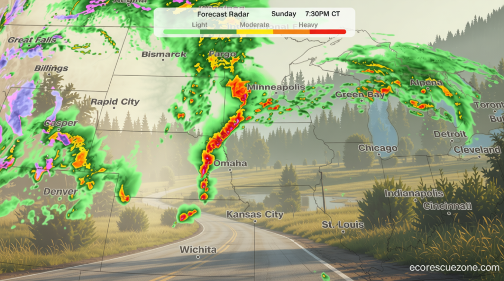
The first wave of storms is expected to develop swiftly in the mid to late afternoon on Sunday, targeting Nebraska and southeastern South Dakota. These thunderstorms will bring heavy rain, gusty winds, and a notable threat of large hail, with the most critical tornado risk emerging in the late evening. From 4 p.m. to 10 p.m. Central Time, the region from eastern Nebraska to western Iowa will face the highest danger, including major cities like Omaha, Lincoln, and Sioux City. The storm’s timing is critical, as early afternoon developments will set the stage for late-night threats.
Forecasters note that the intensity of Sunday’s storms will depend on how early morning conditions interact with the afternoon system. If storm remnants linger into the morning, they may weaken the energy available for the evening’s activity. This uncertainty complicates precise predictions, but the potential for tornadoes remains high. The National Weather Service emphasizes that even a single EF2 or stronger tornado can cause significant damage, particularly in areas with dense vegetation or structures.
“Any fires that ignite in the Southern High Plains Sunday and Monday could spread rapidly due to dry fuels and strong winds,” the National Weather Service cautioned.
Monday: Widespread Outbreak of Severe Weather
Monday is anticipated to bring a broader surge of severe thunderstorms as the jet stream’s energy interacts with ample moisture in the Plains. This interaction is expected to fuel supercells capable of producing tornadoes and large hail. The primary threat zone will stretch from central and eastern Kansas into southeastern Nebraska and northwestern Missouri, with conditions peaking in the late afternoon. However, the most dangerous hours will shift by late evening, when damaging winds and hail will dominate, though isolated tornadoes could still occur into the overnight period.
While the core tornado threat is centered in the Midwest, the storm system’s reach extends into the southern Great Plains. Forecasters highlight that the intensity of these storms is amplified by the interplay of warm, moist air and cooler, drier air masses. This dynamic creates the ideal environment for tornado formation, particularly in areas where the jet stream is strongest. The system’s movement will also bring gusty winds that could topple trees and power lines, especially in open regions with sparse vegetation.
Tuesday: Shifting Storm Pattern and Fire Risk
The storm system will begin to move eastward on Tuesday, with thunderstorms likely to persist from northern Texas through Michigan. While the tornado risk will diminish, the potential for strong to severe storms will increase, particularly in the afternoon. This shift is driven by the dominance of a cold front, which acts as a new trigger for storm development. The primary hazards will transition from tornadoes to damaging winds and hail, with the latter posing a greater threat to infrastructure and agriculture.
Meanwhile, the same system that brought tornadoes to the Central Plains is creating conditions for wildfires in the Southern High Plains. A level 3, extremely critical fire threat is expected Sunday and Monday, with the most severe risk concentrated in southwestern Kansas, the Texas Panhandle, and northeastern New Mexico. A level 2, critical threat will cover a larger area, including much of New Mexico, where dry fuels and low humidity will amplify fire spread potential. Winds of 25 to 30 mph, with gusts up to 50 mph, combined with relative humidity below 10%, will create a volatile environment for any sparks to ignite.
Experts warn that the fire threat will peak as the storm system moves east, leaving behind dry, windy conditions in its wake. The National Weather Service highlights that these conditions could lead to rapid fire growth, especially in areas with dry grasses and forests. While the primary focus of the storm system remains on the Midwest, the Southern High Plains will experience a different set of challenges, requiring preparedness for both weather-related hazards and wildfire risks.
Regional Impacts and Preparedness
Residents in the Central US are advised to monitor updates closely, as the timing and intensity of the storms can change rapidly. The Midwest, including states like Kansas, Nebraska, and Missouri, will need to prepare for the dual threat of tornadoes and severe winds, while the Southern High Plains face the risk of wildfires exacerbated by dry conditions. Emergency management teams are urging communities to prioritize safety measures, such as securing property and having evacuation plans in place.
May is typically a month of frequent severe weather in the Plains, but the current pattern is unusual for its sudden escalation. The suppression of storms earlier in the month was due to a persistent jet stream configuration that kept air masses from colliding effectively. Now that this pattern is breaking, the atmosphere is ripe for extreme conditions. Forecasters suggest that the coming days will test the resilience of communities across the region, with potential for widespread disruptions.
As the weather system evolves, the transition from tornado threats to wind and hail risks will require careful monitoring. The fire danger in the Southwest, while separate, underscores the complexity of the broader weather event. Both the Central US and the Southern High Plains will face unique challenges, but the overall forecast signals a week of heightened weather activity that could impact multiple regions simultaneously. With accurate warnings and proactive preparation, communities can mitigate the risks associated with this storm outbreak.
