Daftar Isi
Residents of Lebanese Village Use Satellite Technology to Monitor War Damage
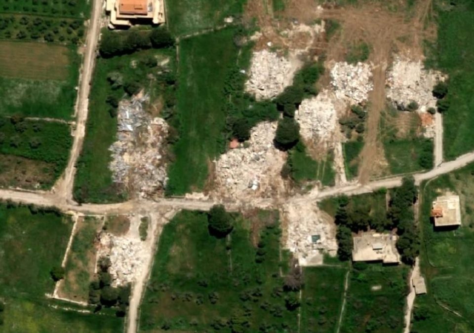
Ecorescuezone.com – On Mazen Farah’s mobile device, grainy but recognizable satellite photographs gradually appear, capturing the Christian quarter of Yaroun, a settlement in southern Lebanon. Though the resolution is somewhat limited, the images reveal enough detail to assess the situation on the ground.
“The satellite view confirms the destruction,” Farah explained while pointing to the screen, describing the two-story stone dwelling constructed by his father following a quarter-century of labor in the Persian Gulf region.
Displacement and Destruction
During March, escalating hostilities involving Hezbollah, an Iranian-supported organization, prompted Israeli military operations that forced hundreds of thousands of people from over one hundred communities across the region.
Following an April 17 truce agreement, Israeli forces deployed heavy machinery to tear down additional structures throughout southern Lebanon. While officials claim these actions target Hezbollah facilities, they seldom offer substantiating documentation or clear explanations for their operations.
Israeli Defense Minister Israel Katz announced in March that his nation planned to clear all Lebanese settlements adjacent to the border, creating what Israeli authorities describe as a permanent “buffer zone” designed to shield northern Israeli populations from potential threats.
Israel currently bars displaced citizens from returning, even for brief visits. Meanwhile, people living in adjacent communities worry about possible Israeli retaliation if they capture photographs or video footage. Consequently, Yaroun residents and others in nearby areas are combining resources to purchase commercial satellite photographs that will show whether their properties remain intact.
“We either purchase images individually or contribute to a shared fund,” Farah noted regarding the process. Each photograph costs a minimum of $112.
Challenges in Obtaining Images
However, satellite service providers frequently inform residents that they cannot supply photographs for particular locations, ultimately returning their payments. During April, several satellite companies refused to deliver images covering Lebanon and neighboring nations following requests from American authorities.
Geryes Saloum, who works for the local municipality, constructed a three-bedroom residence in Yaroun a decade ago. Nearly every neighboring home has now been reduced to rubble.
“Each day I anticipate receiving a photograph from Yaroun,” said Saloum, employed by the water utilities department. “When Mazen’s house was demolished three days ago, I couldn’t sleep at all.”
Saloum recalled that following the November 2024 ceasefire, United Nations agencies and humanitarian organizations invested millions of dollars repairing water and electrical infrastructure. “We believed the conflict had ended and no further wars would come,” he stated. Yet in March, as American and Israeli forces targeted Iran, the violence expanded once more, reaching southern Lebanon.
Widespread Damage to the Village
Hafez Ghacham, the mayor of Yaroun, reported that Israeli military operations have demolished 180 of approximately 200 homes in this mixed Christian and Muslim community since hostilities resumed in March.
The Israeli military declined to comment when NPR requested information about the village destruction.
The current conflict originated in October 2023, one day following Hamas militants’ devastating assault on southern Israel from Gaza, which ignited the broader Gaza war. By the time a ceasefire was established the following year, Israeli bombardments had obliterated most of Yaroun’s essential infrastructure.
“In the village they destroyed the landmarks, they destroyed the convent, they destroyed the church, they destroyed three mosques,” along with another Shiite Muslim religious center, explained Riad al-Ridha, a village official. “All the cultural landmarks in our village were destroyed — they have erased it.”
After the Greek Catholic Saint George church suffered an airstrike that left only two exterior walls standing, displaced villagers continued worshipping in a nearby church hall. They have since been prohibited from returning. During early May, Israel demolished a convent and a Catholic school that had served both Christian and Muslim students for fifty years.
Israeli authorities repeatedly denied destroying the convent despite satellite imagery and video documentation, instead presenting photographs of a different building they claimed was the convent.
Yaroun belongs to the Galilee region, a geographic area extending into modern Israel. This territory holds religious significance as the place where Jesus is believed to have preached and performed miracles.
Among Lebanon’s scenic villages, Yaroun was renowned for its beauty. Traditional and contemporary stone residences adorned a hillside covered with olive and citrus trees. An ancient oak forest, now leveled, had existed for hundreds of years.
Some homes are modest structures dating back two centuries, while others, constructed from local stone with red-tiled roofs, resemble palaces. The village sits 2,600 feet above sea level, contributing to its distinctive character and appeal.
Related Reading
Frequently Asked Questions
What is Lebanese displaced by war turn to satellites?
Lebanese displaced by war turn to satellites is the main topic of this guide. The article explains the context, practical details, and next steps readers should understand.
Why does Lebanese displaced by war turn to satellites matter?
Lebanese displaced by war turn to satellites matters because readers are looking for a useful answer, not just a short summary. Good content should match search intent and help them decide what to do next.